

Click 'Get Pricing' to add this to a quote and access pricing information. After submission, get a response within 3 business days.
The MultiScape200 CIS brings more in-depth insight with more spatial and spectral detail to each pixel. Engineered to fit in a 12U volume makes the MultiScape200 CIS ideal for any 16U or larger platform. Thanks to an advanced thermal design, satellite operators can use the MultiScape200 CIS over a wide temperature range, for longer.
Features:
- 1.5 m GSD (at 500 km orbit height)
- Swath width of 14 km (at 500 km orbit height)
- 7 spectral bands in the VNIR range
- 12-bit pixel depth
- 128 Gigabyte non-volatile storage capacity for up to 2 000 km strip (at 500 km orbit height)
- On-board image processing and compression capabilities
- Comprehensive telemetry and health monitoring including OFE temperature measurement
- Latch-up current monitoring and optional on-board power switch with quick turn-off
- Inject AOCS/ADCS parameters and time information into data stream
- Expected lifetime of more than 5 years
- For more technical details see Documents tab below
Applications:
- Precision agriculture
- Forestry and land use
- Energy and infrastructure
- Coastal monitoring
- Air quality
- Resource and infrastructure monitoring
The signal-to-noise ratio with a selection of dTDI stages, at an orbit height of 500 km is shown in the Figure below. An at-aperture radiance function of 100 W·m-2·sr-1·µm-1 is assumed across the spectral range for all of the SNR values. The transmittance of each band is also shown.
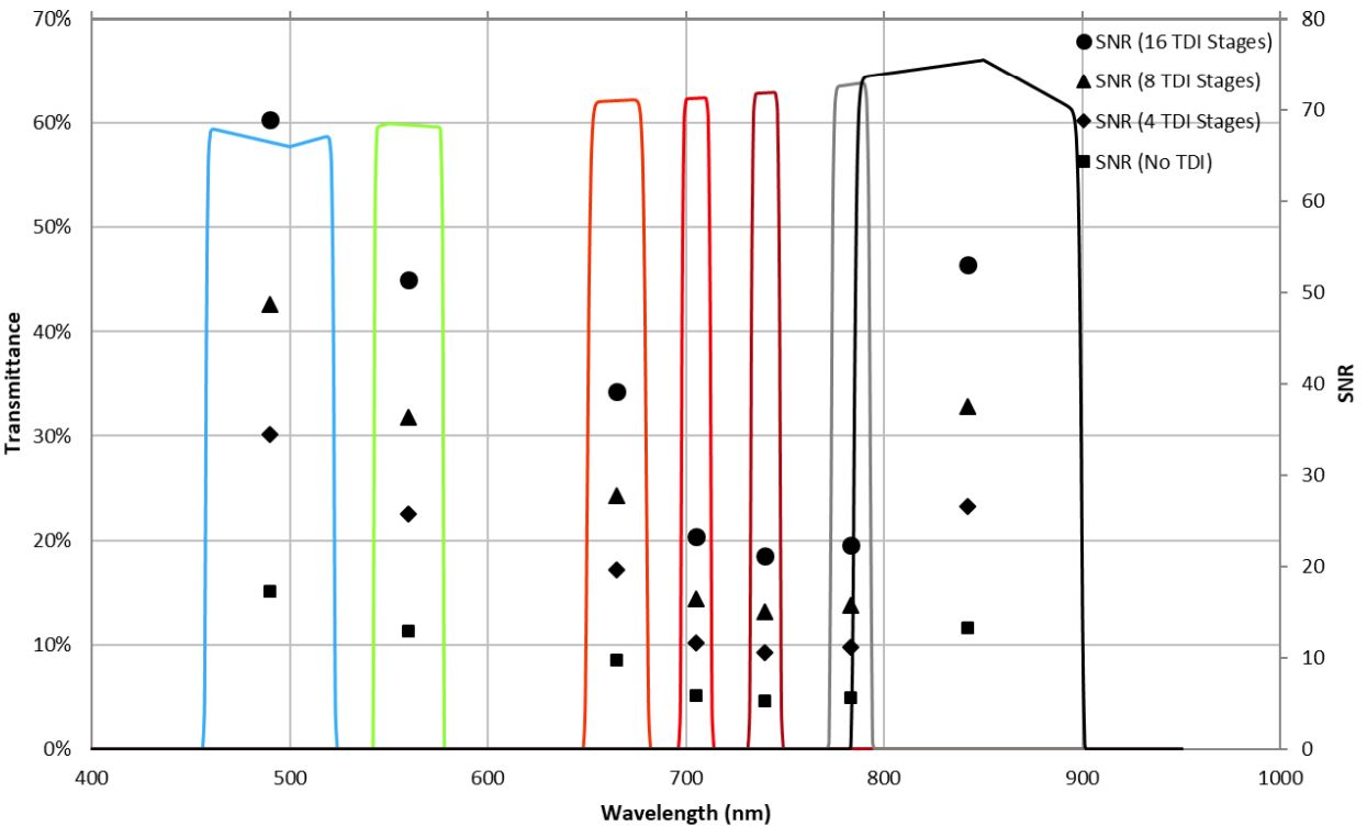
Figure: SNR and Transmittance
| Parameter | Value |
|---|---|
| Type | Earth Observation |
| Sensor Technology | CMOS |
| Sensor Type | Line Scan |
| Resolution | 9344 Pixels (Cross Track) |
| Pixel Size | 3.2 µm |
| Pixel Depth | 12-bit |
| Number of Spectral bands | 7 |
| Line Rate | 8000 Hz |
| Ground Sampling Distance | 1.5 m (at 500km orbit) |
| Swath Width | 14 km (at 500km orbit) |
| Storage Capacity | 128 GB |
| Supply Voltage | 5 V |
| Maximum Power Consumption | 5.8 W |
| Typical Power Consumption | 2.5 W |
| Mass | 12.1 Kg |
| Dimensions | 216 x 216 x 304 mm |
| Operating Temperature Range | -10C to 50C |
| Survival Temperature Range | -20C to 60C |
| Type | Document Name | Action & Size |
|---|---|---|
| No public documentation available. Please inquire for details. | ||