

The MultiScape100 CIS is designed with a single goal in mind, to capture the earth in greater detail, more depth and a wider range of spectral bands within a 3U and 6U CubeSat form factor. This imager is based on a global shutter CMOS image sensor and a multispectral filter in the visible and near-infrared (VNIR) spectral range, each with up to 32 digital time delay integration (TDI) stages.
Features:
- 4.75 m GSD (at 500 km orbit height)
- Swath width of 19.4 km (at 500 km orbit height)
- 7 spectral bands in the VNIR range
- 128 Gigabyte non-volatile storage capacity for up to 18 000 km strip (at 500 km orbit height)
- On-board image processing and compression capabilities
- Comprehensive onboard telemetry and health monitoring
- Latch-up current monitoring and optional on-board power switch with quick turn-off
- Inject AOCS/ADCS parameters and time information into data stream
- Option to integrate pulse per second signal
- For more technical details see Documents tab below
Applications:
- Precision agriculture
- Forestry and land use
- Energy and infrastructure
- Coastal monitoring
- Air quality
- Resource and infrastructure monitoring
The signal-to-noise ratio with a selection of TDI stages, at an orbit height of 500 km is shown in the Figure below. An at-aperture radiance function of 100 W·m-2·sr-1·µm-1 is assumed across the spectral range for all of the SNR values. The transmittance of each band is also shown.
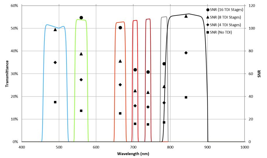
Figure: SNR and Spectral efficiency.
- Type:
- Earth Observation
- Sensor Technology:
- CMOS
- Sensor Type:
- Line Scan (push broom)
- Resolution:
- 4096 pixels (Cross Track)
- Pixel Size:
- 5.5 µm
- Pixel Depth:
- 12-bit
- Number of Spectral Bands:
- 7, across Visible & NIR
- Line Rate:
- Up to 4000 Hz
- Ground Sampling Distance:
- 4.75 m (at 500 km orbit)
- Swath Width:
- 19.4 km (at 500 km orbit)
- Storage Capacity:
- 128 GB
- Mass:
- 1.1 kg
- Dimensions:
- 98 x 98 x 176 mm
- Operating Temperature Range:
- -10C to 50C
- Radiation Tolerance:
- Up to 15 krad
- Maximum Power Consumption:
- 5.8 W
- Typical Power Consumption:
- 2.5 W
- 4.75 m GSD (at 500 km orbit height)
- Swath width of 19.4 km (at 500 km orbit height)
- 7 spectral bands in the VNIR range
- 128 Gigabyte non-volatile storage capacity for up to 18 000 km strip (at 500 km orbit height)
- On-board image processing and compression capabilities
- Comprehensive onboard telemetry and health monitoring
- Latch-up current monitoring and optional on-board power switch with quick turn-off
- Inject AOCS/ADCS parameters and time information into data stream
- Option to integrate pulse per second signal
- For more technical details see Documents tab below
- Precision agriculture
- Forestry and land use
- Energy and infrastructure
- Coastal monitoring
- Air quality
- Resource and infrastructure monitoring
The MultiScape100 CIS is designed with a single goal in mind, to capture the earth in greater detail, more depth and a wider range of spectral bands within a 3U and 6U CubeSat form factor. This imager is based on a global shutter CMOS image sensor and a multispectral filter in the visible and near-infrared (VNIR) spectral range, each with up to 32 digital time delay integration (TDI) stages.
Features:
Applications:
The signal-to-noise ratio with a selection of TDI stages, at an orbit height of 500 km is shown in the Figure below. An at-aperture radiance function of 100 W·m-2·sr-1·µm-1 is assumed across the spectral range for all of the SNR values. The transmittance of each band is also shown.
Figure: SNR and Spectral efficiency.